By Air and Sea, Synthesis Research is Improving How Scientists Capture the Big Picture on Ecosystem Change

Our planet’s ecosystems are changing fast. To keep the scientific understanding apace with these changes, experts are in increasing need of new research methods that can help reveal the bigger picture on these changes and their potential future impacts.
Synthesis science is helping to meet this need. As melting pots of varied knowledge and perspectives, synthesis working groups are well positioned to expose gaps and differences data and methodologies. The resulting drive to reconcile these deficiencies and differences can lead to new methods that are often more broadly applicable and effective at helping researchers answer difficult questions, which can mean better science for decision-making.
“New data sources, innovative methods and tools are really increasing the productivity and power of synthesis research,” says Frank Davis, who has led many a synthesis working group and is now director of the Long-Term Ecological Research Network Communications Office, which is operated out of NCEAS.
Two recent NCEAS working groups exemplify what can result from such synergies. One has homed in on a more precise way to monitor something that’s notoriously hard to track - biodiversity change - by taking observations from the air. The other has refined the capacity to assess outcomes of management actions on an economically and ecologically important marine fishery, the Gulf of Alaska.
Monitoring Global Biodiversity Takes Flight
Biodiversity is changing quicker than we can track it. Scientists around the world are on a time-sensitive mission to understand these changes to help managers develop effective strategies for protecting this important ingredient for healthy ecosystems.
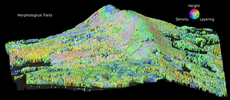
Our first group of researchers tested and now propose using remote sensing as a solution for collecting the enormous amount of data needed to monitor biodiversity change. This method uses sensors that are mounted on orbiting satellites or flying aircrafts to detect the energy reflected from the Earth’s surface and transmit data, which can help scientists determine where the most biodiversity change is happening, what is causing it, and what are best ways to protect vulnerable regions.
“Biodiversity and remote sensing were largely disjointed activities in the past,” says Michael Schaepman, a working group member and professor at the University of Zurich. “But technological advances in both fields and the use of synthesis science to monitor changing biodiversity have led to a more impactful methodology for tracking global biodiversity change.”
Monitoring biodiversity is infamously hard to do, especially in developing or remote areas, in part because scientists typically do it by observing sample plots on the ground. The problem is there aren’t enough people and resources to return to these regions to collect data continually, which is key to tracking changes over time.
“This means we know least about the areas that we’re most concerned about,” said David Schimel, an ecologist with the Jet Propulsion Laboratory and principal investigator of the working group.
For example, Schimel explained, while researchers have established over two million monitoring plots in the United States, only two percent of them have ever been revisited.
With remote sensing, scientists will be able to cover lots of ground relatively easily, giving them a better bird’s eye view, so to speak, on global biodiversity change.
For their work, Schimel, Schaepman, and their team focused on monitoring changes in plant biodiversity, which is linked to many ecosystem services, such as water quality and nutrient cycling, and thus has important implications for overall ecosystem health. They collected data such as leaf thickness, nitrogen concentrations, and chlorophyll from across large swaths of land, which will allow the researchers to identify hotspots where plant characteristics are changing more or less rapidly.
The team used aircraft-mounted sensors, which are relatively lower in cost and easier for data retrieval compared to using satellites. Eventually, they hope to use satellites, which can collect data more frequently and have wider spatial coverage. This advancement may be on the horizon as NASA, inspired by the working group’s findings, has pledged $650 million to employ its satellites to monitor plant biodiversity as one of their first missions after 2020.
“As the costs of remote sensing technologies go down, we’ll see it used in a wider range of applications and fields that will ultimately inform better policies for conservation and sustainability,” said Schaepman.
A More Holistic Model for Future Fisheries
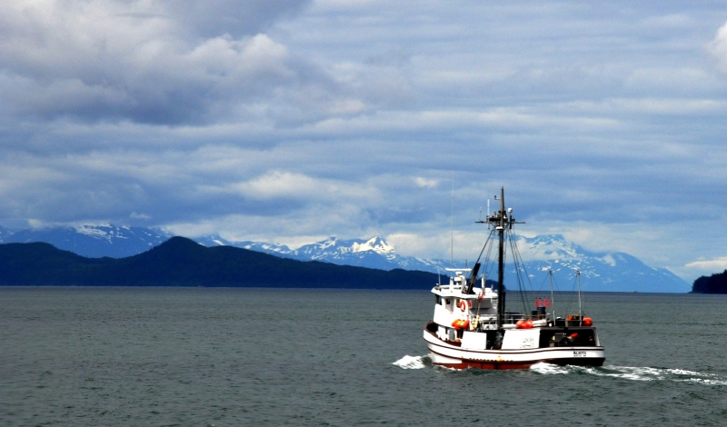
With over 30 thousand miles of coastline covered by thick forests, craggy mountains, and coastal glaciers, the Gulf of Alaska supports one of the most productive coastal ecosystems and commercial fisheries in the world, as well as robust sports fishing and wildlife tourism industries.
As with most commercial fisheries, fishing pressures and a changing climate are threatening the region’s long-term productivity, leading to declining fisheries and cascading impacts on the ecological food web and local tourism.
While managers grapple with how to sustain commercially important fish, there is also a need to get a bigger picture of the entire food web, including humans. Without a comprehensive understanding of the system, species-specific management can lead to unforeseen impacts on not just other commercially important fish, but also the local wildlife, economy, and culture.
Enter our second working group. They wanted to know what would happen if management strategies favored one fish species over another and whether those decisions would have unintended consequences on the rest of the Gulf’s food web, economy, and culture.
However, the modeling capacity to answer such questions was not quite there yet.
So, the working group – comprised of ecologists, economists, and social scientists – developed a detailed food web model of the Gulf, which integrates ten years of ecological, environmental, and socio-economic data to understand what factors affect commercial fish populations.
“One of the benefits of synthesis research is that it can take advantage of disparate datasets to show us how ecosystems really function,” said Jim Ruzicka, a principal investigator and research associate at Oregon State University. “You can have highly detailed data on individual fish species, but without the whole ecological and human food web, you can’t really understand what factors affect the target fish species.”
Rather than reinventing the wheel, Ruzicka and his colleagues adapted an older model that was created earlier by one of the working group members with the National Oceanic and Atmospheric Administration (NOAA), which uses data collected in the 1990s. By enhancing this model with more recent data and incorporating a host of other important variables – such as predatory-prey interactions; El Niño and other meteorological events; and socio-economic factors such as fishing behaviors – the team created a tool that provides that bigger picture.
With these new features, the model is able to calculate potential impacts of management decisions or disturbances not only throughout the whole food web but also to the region’s economy.
“Our food web model can run investigative scenarios to answer ‘what if’ questions,” explained Ruzicka. “What would happen to the fishery if there was another oil spill in the Gulf of Alaska? How would the ramifications echo throughout the ecosystem? How long would it take for the economy to recover?”
Importantly for the model’s usefulness, the team also made sure managers will be able to access it. They developed it on a new, user-friendly modeling platform that can run on any computer and be used by any modeler. At the time of writing, the model was still under review, but it will be available on the Biological and Chemical Oceanography Data Management Office website.
According to Tom Okey, a co-principal investigator and president of Ocean Integrity Research, continued support of similar models derived from synthesis will be essential for expanding our understanding of ecosystem change.
“Integrating knowledge from ecological and socio-economic fields is bringing a renaissance in understanding complex ecosystems and living sustainably with them,” he said.