NCEAS’ SeaSketch program makes strides towards global 30 by 30 goal
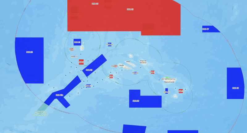
Will McClintock, a senior fellow at NCEAS and head of SeaSketch, scans the digital ocean surrounding The Azores, a small archipelago off the coast of Portugal. From where he is sitting, he can view newly proposed plans for marine protected areas, or MPAs, within an 800-kilometer radius of these volcanic specks of land. “Let’s see,” he says, locating the MPAs and hovering over São Jorge, Ilha das Flores, and Ilha Terceira.
McClintock is sitting at his desk at NCEAS in Santa Barbara, California. After a series of clicks, he can view the nitty gritty details of the proposed MPAs, including which fishing activities would be allowed in each polygon.
In total, these MPAs encompass nearly 300,000 square kilometers of the North Atlantic Ocean. The plans have passed through a public comment period and now await the signature of The Azores president. If the MPAs are accepted into law, The Azores would achieve their share of the UN’s Global Biodiversity Framework goal for 30% of marine areas protected by 2030 (aka, 30 by 30) – a feat that few nations have yet to claim, including the United States.
How has a small archipelago managed to get this far so quickly? The answer is in part due to SeaSketch, a unique collaborative GeoDesign software platform developed by McClintock and his team at NCEAS.
SeaSketch vastly increases the efficacy of local marine conservation planning by allowing the public, scientists, and local resource managers to combine local knowledge and authoritative geospatial data. SeaSketch developers and users then create maps and reports from this data to optimize both the protection of marine habitat and sustainable ocean activities. Once finalized, the plans move through local government requirements, such as public comment and executive approval. This collaborative process allows stakeholders to clearly articulate their interests and understand those of others. The result reduces the chance for lengthy, expensive litigation and increases the chance for public support and adherence.
McClintock, a biologist by training, has been working in marine spatial planning since 2004. For nearly 20 years he has helped shape the field, first in California and now on a global scale. But he says he couldn’t have predicted the growth that has now culminated in SeaSketch. McClintock was always looking to his colleague, another biologist, for that technical vision.
If McClintock is the head of SeaSketch, Chad Burt is the hand. Burt is the principal developer of SeaSketch and has been working with McClintock since 2004. At the time, Burt was a marine research diver, powering through bouts of seasickness to pursue his affinity for ocean biodiversity. Computer programming was just his hobby. But as Google Maps emerged as a popular public tool, Burt saw an opportunity to shift careers and rest his weary sea legs. So he dedicated himself to coding and data visualization, hoping to make improvements to the conservation planning process, which was technically cumbersome and often politically divisive.
Burt and McClintock both worked on California’s Marine Life Protection Act Initiative (MLPAI) between 2004 and 2011, through ups and downs. Efforts to develop MPAs prior to the MLPAI succeeded in designating data-driven MPAs around the Channel Islands, but the plans faced backlash from tourism and recreation stakeholders, who wanted more voice in the process.
Burt remembers asking himself, “if we can make the best thing possible, what would it look like?”
He wanted a tool that would be both accessible to a broad audience of stakeholders and applicable to a wide array of locations. Burt and McClintock got to work, using a combination of Esri, open-source, and custom software to develop such a tool. They called it SeaSketch, a name that hints at how users can “sketch” ideas for MPAs onto a map.
A SeaSketch project is usually initiated by a government that is committed to certain marine protection goals, such as the UN’s Global Biodiversity Framework. Once a stakeholder group is convened, SeaSketch developers get involved to help manage the geospatial data, train local teams of scientists, and coordinate on-the-ground surveys of local perspectives. The surveys inform scientists which areas are valued most for fishing, tourism, and other sectors. Then the survey data is combined with environmental geospatial data, such as critical species habitat, in SeaSketch.
Stakeholders then analyze different MPA designs to see which might be most effective towards achieving the local government’s conservation and sustainable-use goals. A public forum feature allows for stakeholders to comment on and revise MPA sketches. This transparency in communication and planning goes a long way to build trust among stakeholders, dispel doubts about MPAs, and ease potential conflicts.
“You certainly don’t need to be a marine ecologist or planner [to use SeaSketch],” Burt says. In fact, fishers and other people who rarely use computers are able to successfully use the interface to collect survey data, use the mapping features, and participate in the built-in discussion forums.
After 20 years in the making, SeaSketch continues to evolve. Constraints on expensive third-party data hosting and the capacity of the NCEAS SeaSketch development team are easing this year thanks to a new open-source format and cloud-based data storage. Now anyone with coding skills can develop their own analytical reports, rendering the tool even more customizable to project goals. SeaSketch can also provide free data hosting, which will undoubtedly increase accessibility for countries that don’t have their own infrastructure, Burt says.
Accessibility, both in technical and social terms, is a significant reason why Burt and McClintock dedicate themselves to this work. To that end, McClintock prioritizes site visits for the development team so that they can be familiar with the people using their software.
McClintock, just after returning to NCEAS from a site visit in Belize, recalls the difference SeaSketch can make to those with no technical or scientific background: “People are kind of anxious…they know they’ve been asked to come to the table because they have some stake in the game, but once they see the tool, they see the maps, they really start to get, ‘this is what they mean by marine planning.’”
From The Azores to NCEAS to Belize, and everywhere in between, the public can experience that high altitude view of marine spatial planning and dive into the details on what MPAs may look like on the water. To view the proposed MPAs in The Azores, and other ongoing SeaSketch projects, visit www.seasketch.org.